The Mazi Plain (also known as the Mazi Basin or Oinoe Plain) is situated in the northwestern part of the modern prefecture of Attica, some 16 km North of Eleusis and 20 km South of Thebes. The plain is bounded to the north and south by the Kithairon-Pastra and Makron mountain ranges respectively. Several mountain streams flow into the plain and gather at its southeastern extremity, forming the Eleusinian Sarantapotamos. The plain is fertile and well-watered: the valley bottom is now almost entirely dedicated to agriculture, mostly crops and vine. The surrounding slopes, dominated by limestone, are covered with a thick maquis and pine forests. Except for a few homes and farms surrounding the modern town of Oinoe (formerly called Mazi), the plain is relatively sparsely occupied.
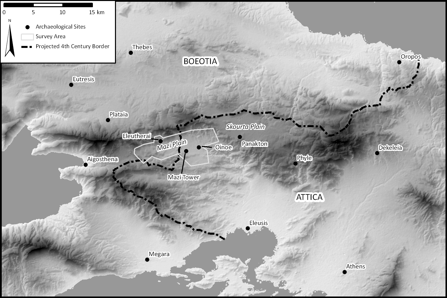
General map of the area, showing northern Attica, southern Boeotia and the Megarid.
Historically, the Mazi plain was situated in the Attic-Boeotian borderlands (Thucydides 2.18.1-2), a situation that endures today. Centrally located on the main route between Eleusis and Thebes, the valley also occupies a critical crossroads on regional and interregional land routes. From the Late Archaic period onward (at the latest), the valley was settled and farmed by two major settlements, the Attic deme of Oinoe to the east and the town of Eleutherai to the west. While the work of MAP is concerned with all aspects of the long-term history of the Mazi Plain, these two sites, along with the Mazi Tower, are particularly well known landmarks.
The Deme of Oinoe
Oinoe, of the Hippothontis tribe, is called a “demos on the eschatai of Attica” by Herodotos (5.74.2). As a border deme, it was especially exposed to foreign attacks and raids. The Boeotians attacked the settlement in 506 BCE . At the outbreak of the Peloponnesian War, in 431 BCE, Oinoe was the first Attic town to sustain a siege by the Peloponnesians, led by Archidamos (Thucydides 2.18.1-2). The failure of Archidamos to capture the town testifies that it was already well fortified at the time. Unfortunately, the archaeology of the site is poorly known.
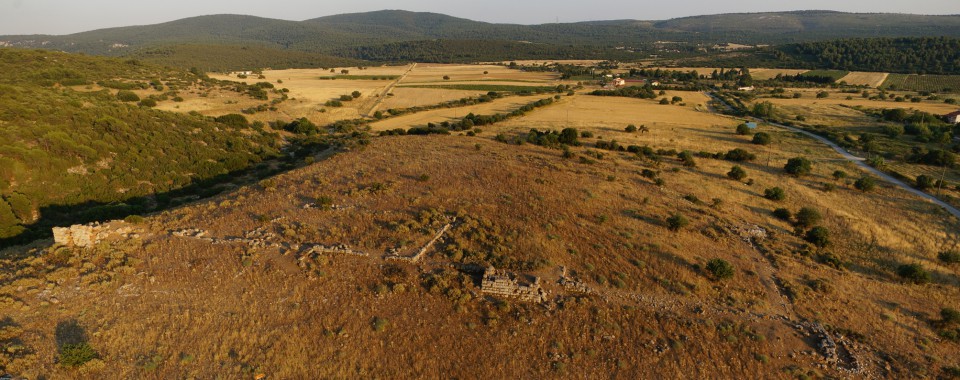
View of Oinoe from the north.
One of the first tasks of MAP was to draw a precise plan of the remains. At this stage of the study, three main building phases can be distinguished: a Classical phase, with walls and towers built of limestone blocks and a mud brick elevation; a Hellenistic phase of conglomerate ashlar blocks, defended by massive towers; and a Byzantine phase, during which the ancient walls were repaired and an extension of the settlement was built on the south and southwest side of the main site. The intensive field survey of the settlement recorded an abundant surface material which includes tiles, fine and coarse pottery, including pithoi and beehives. The material suggests that Oinoe was continuously occupied from the late Archaic to the Late Roman period, and again in Byzantine times, when it was known as Myoupolis/Nyoupolis.
Eleutherai
On opposite (west) side of the plain, 6 km west of Oinoe, are the town and fortress of Eleutherai, situated at the foot of the Kaza Pass. Its origin is Boeotian, but the town latter switched political affiliations between Attica and Boeotia over several centuries. However, Eleutherai never became an Attic deme. Archaeological research has revealed the existence of a fourth-century Doric temple, a shrine of Herakles, two basilicas, various buildings and a necropolis. The town was partially ruined at the time of Pausanias’ visit in the 2nd century CE (1.38.9).
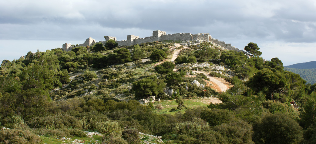
The fortress of Eleutherai, seen from the northwest.
Above the town of Eleutherai lies a spectacular fortress, which is among the best-preserved in Mainland Greece. The north and west walls were built entirely of stone, well protected by eight rectangular towers. Two monumental gates were built at the southwest and southeast corners, allowing traffic to pass through the fortress. Unfortunately, the changing political status of Eleutherai leaves the question of the construction of the fortress unresolved. Long thought to have been one of the major Athenian fortresses defending entry into Attica, the fortification above Eleutherai now seems to have been built in the first half of the 4th century BCE by the Boeotians (see Fachard 2014 on the Resources page of this site for a summary of this debate and further references).
The Mazi Tower
The impressive remains of this ancient tower have monopolized the attention of travelers since the 19th century, often overshadowing the site of Oinoe. With a square plan of ca. 9 x 9 m, the tower is one of the largest in Attica. It is currently preserved to a height of 14 m, providing support for five stories. The function of the tower has long seemed to be military, offering an outpost for Athenian troops guarding the Eleutherai-Eleusis road. However, alternative interpretations (characteristic of rural towers in Greece in general) suggest that it could also be a farm tower.
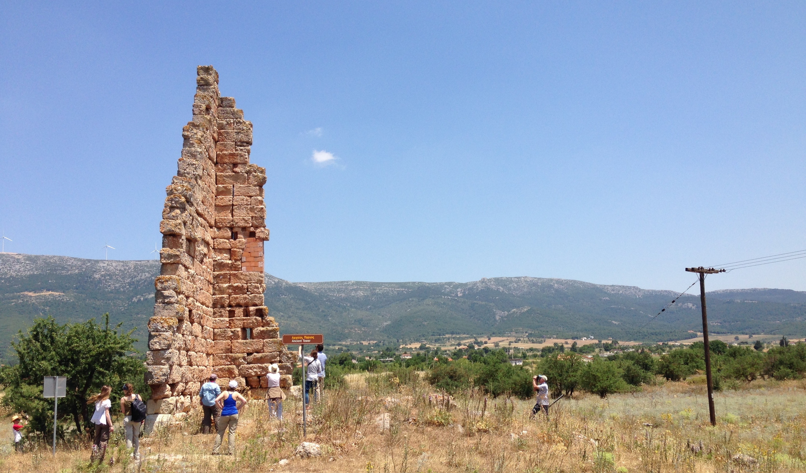
The Mazi Tower, seen from the south.